


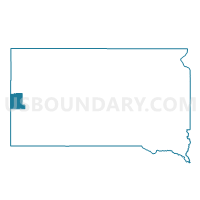
VTD - Nemo precinct, Lawrence County, South Dakota
About
Outline

Summary
| Unique Area Identifier | 667450 |
| Name | VTD - Nemo precinct |
| County | Lawrence County |
| State | South Dakota |
| Area (square miles) | 128.09 |
| Land Area (square miles) | 128.08 |
| Water Area (square miles) | 0.02 |
| % of Land Area | 99.99 |
| % of Water Area | 0.01 |
| Latitude of the Internal Point | 44.21144130 |
| Longtitude of the Internal Point | -103.57700450 |
Maps


Graphs
Select a template below for downloading or customizing gragh for VTD - Nemo precinct, Lawrence County, South Dakota


Neighbors
Neighoring Voting District (by Name) Neighboring Voting District on the Map
- VTD - JS5, Pennington County, SD
- VTD - R13, Pennington County, SD
- VTD- Rural 1 precinct, Lawrence County, SD
- VTD-precinct 11 - Piedmont, Meade County, SD
- VTD-precinct 16 - W.BlackHawk, Meade County, SD
- VTD-precinct 6 - Tilford, Meade County, SD
Top 10 Neighboring County Subdivision (by Population) Neighboring County Subdivision on the Map
- Southwest Meade UT, Meade County, SD (11,199)
- Mount Rushmore UT, Pennington County, SD (6,802)
- South Lawrence UT, Lawrence County, SD (2,017)
- West Pennington UT, Pennington County, SD (1,647)
Top 10 Neighboring Unified School District (by Population) Neighboring Unified School District on the Map
- Rapid City School District 51-4, SD (91,522)
- Meade School District 46-1, SD (18,211)
- Lead-Deadwood School District 40-1, SD (6,625)
- Hill City School District 51-2, SD (3,196)
Top 10 Neighboring State Legislative District Lower Chamber (by Population) Neighboring State Legislative District Lower Chamber on the Map
- State House District 33, SD (26,472)
- State House District 29, SD (25,322)
- State House District 30, SD (24,446)
- State House District 31, SD (24,097)
Top 10 Neighboring State Legislative District Upper Chamber (by Population) Neighboring State Legislative District Upper Chamber on the Map
- State Senate District 33, SD (26,472)
- State Senate District 29, SD (25,322)
- State Senate District 30, SD (24,446)
- State Senate District 31, SD (24,097)
Top 10 Neighboring 111th Congressional District (by Population) Neighboring 111th Congressional District on the Map
Top 10 Neighboring Census Tract (by Population) Neighboring Census Tract on the Map
- Census Tract 203.01, Meade County, SD (7,475)
- Census Tract 9666, Lawrence County, SD (4,836)
- Census Tract 117, Pennington County, SD (4,104)
Top 10 Neighboring 5-Digit ZIP Code Tabulation Area (by Population) Neighboring 5-Digit ZIP Code Tabulation Area on the Map
- 57702, SD (32,980)
- 57718, SD (6,307)
- 57754, SD (3,793)
- 57769, SD (3,515)
- 57745, SD (2,109)
- 57732, SD (1,979)
- 57759, SD (546)